1st Issue, December 2014

ATMAPS - Specification of symbols used on audio-tactile maps for individuals with blindness
Newsletter No. 1
Welcome to the first Newsletter of the ATMAPS project. In this newsletter, we would like to inform you about the project "Specification of symbols used on Audio-Tactile Maps for individuals with blindness (ATMAPS)", the reasons why we initiated the project, who is involved, and what the project's activities are.
The Project ATMAPS is supported by the European Commission in the Lifelong Learning Programme from January 2014 until December 2016.
Project idea
The ATMAPS project brings basic educational and training needs as well as problems and challenges of individuals with blindness into focus.
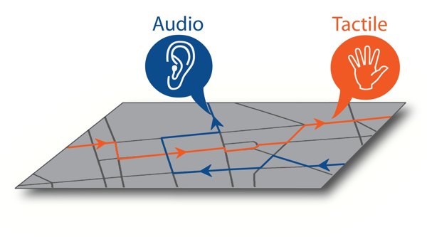
Orientation and mobility are the most important issues for persons with blindness. Thus, we initiated this project in order to make significant contributions towards the construction of Audio-Tactile Maps as aids to improve orientation and mobility of the particular group. Traditionally, tactile maps are used for better orientation. However, we believe that adding audio information to tactile maps makes it easier for users with blindness to get to know new surroundings. In the case of Audio-Tactile Maps, information is represented by audio symbols, tactile symbols, audio-tactile symbols (combined) and Braille labels.
In this project, we pursue two main goals.
Firstly, we want to derive from individuals with blindness what information is important for them on a map and how it should be represented (as a tactile symbol, as audio information or as an audio-tactile symbol).
Secondly, we want to specify these audio-tactile symbols in order to be used in Audio-Tactile Maps for education and training of individuals with blindness.
After the specification of the audio-tactile symbols we will make them publicly available, create Audio-Tactile Maps and train individuals on how to create those maps and how to use them. All material such as audio-tactile symbols, maps and training material will be freely available on the project's website (www.atmaps.eu).
During the project, we perform various studies in order to derive from users with blindness from different countries, what their needs and preferences are. We are very grateful that over the past months so many individuals were willing to contribute and cooperate with the project team and would like to thank everyone who already participated in our studies.

Who is involved?
There are seven partner organizations from four countries working together in this project. All of them bring a different perspective to the project according to their profile.
- University of Macedonia (UOM) (www.uom.gr) in Thessaloniki, Greece, as the project's leading partner is in charge of the overall coordination and representation of the project. The Department of Educational and Social Policy of UOM was established in an effort to promote among others research in the fields of education of individuals with disabilities, training techniques, development and evaluation of social policy regulations. In this context, extended research is conducted by the department on a range of vital subjects of visual impairment and blindness, such as spatial knowledge, cognitive maps, assistive technology, perception and comprehension of synthetic speech, tactile maps, orientation & mobility of the visually impaired, adaptive behavior, and social support.
- Karlsruhe Institute of Technology (KIT) (www.kit.edu) with its Study Centre for the Visually Impaired (SZS) (www.szs.kit.edu) in Karlsruhe, Germany supports and advises visually impaired students and prospective students in all fields offered at KIT. A cross-disciplinary team continuously develops innovative and individual solutions for accessible studies, especially in STEM fields. Together with the Chair of Computer Systems for Visually Impaired Students, the SZS does research on assistive technologies and on how to get new access to STEM fields.
- National and Kapodistrian University of Athens (UoA) is the oldest and largest university in Greece, with 32 Departments, 2.100 members of the Academic Staff and more than 62.000 students. The research interests of the Speech and Accessibility Laboratory, Department of Informatics and Telecommunications (http://speech.di.uoa.gr) focuses on the area of Computer Accessibility and Voice User Interfaces, as a part of the major domain of Human-Computer Interaction.
- Mustafa Kemal University (MKU) (www.mku.edu.tr) is a large public university located in Hatay, Turkey. Following the modern developments, undertakes to correspond universal values with regional and national values and to find solutions for the problems of the country and the world. MKU aims for continuous improvement of our community providing different services that will result in productive and self-reliant individuals. MKU is a large public university with approximately 30.000 students and 1500 employees that operates in many different disciplines (with 14 faculties. 6 four year vocational schools, 18 two year vocational schools, a conservatory and 17 research centers).
- GeoImaging Ltd (GI) (www.geoimaging.com.cy) is a leading SME in Cyprus, established in 2002 at Nicosia. The company offers scientific and professional solutions in Geo-informatics. It is also active in Research and Development (R&D) programmes, in EU & national funded projects and provides consultations services as well. The services and consultations of GeoImaging are tailored towards Geo-informatics area that helps public and private sector succeed with improving their performance and implementing projects.
- Panhellenic Association of the Blind (PAB) (www.pst.gr) established in 1932 and it is the first organization of the blind for the blind and for all the other individuals with disabilities in Greece. It is a nationwide scale primary union of federal type with 9 regional associations in Greece. The Panhellenic Association of the Blind in Thessaloniki operates service offices for: secretarial and accounting support, borrowing library with accessible audio books, European programs activities, orientation and mobility and daily living skills for education services, social services aiming at psychosocial support for individuals with visual impairments and a network of volunteers to meet the needs of its members
- Association of Barrier Free Access (ABFA) (www.engelsizerisim.com) from Istanbul in Turkey is a non-profit activist organization. Its main purpose is to remove barriers which prevent equal opportunity, physical access and social integration of individuals with disabilities. Parallel with the social model we believe that disability is a part of human diversity rather than a handicap. Thus, the physical and social barriers and prejudices make people disabled not their physiological characteristics.
Aims and Objectives
The fundamental aim of the ATMAPS project is the research based specification of audio, tactile and audio-tactile symbols to be applied on a wide spectrum of different types of maps, frequently used in education and training of individuals with blindness.
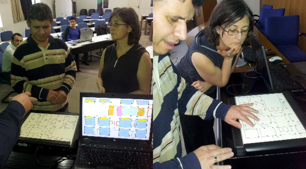
Tactile maps are an important aid for the orientation and movement of individuals with blindness. Classic tactile maps include raised graphic patterns and Braille labels that are recognizable only by touch. Nowadays, technology allows the integration of audio information to tactile maps with the use of special devices. Audio-touchpad devices are touch sensitive pads that can simultaneously provide users with tactile and audio information, while they explore tactile graphics by their fingers. A specifically prepared tactile map printed with a tactile embosser is placed on the device's touch sensitive pad and additional audio information like streets names, landmarks, historical information etc. are stored in a separate file. The audio information can then be accessed by tapping on a specific tactile symbol on the Audio-Tactile Map.
In the project, the focus also lies on the training of teachers of individuals with blindness, rehabilitation specialists, orientation and mobility trainers as well as designers of orientation and mobility aids, on the construction of Audio-Tactile Maps and on the use of audio-touchpad devices.

Activities
The project is divided into different phases:
Phase 1: Specification of user requirements and definition of which information should be represented, in audio, which in tactile and which in audio-tactile form.
Phase 2: Development of audio-tactile symbols, production of pilot Audio-Tactile Maps, testing of audio-tactile symbols and audio-tactile symbol specification activities. The results will be presented at the project's multi-lingual website.
Phase 3: Production of audio-tactile material to be freely available on project's website. Development of a web-based electronic library of audio-tactile symbols and construction of a political-physical audio-tactile atlas.
Phase 4: Production of training material for end-users to enable them to produce Audio-Tactile Maps for individuals with blindness.
Phase 5: Implementation of a series of seminars for end-users on the construction of Audio-Tactile Maps and on the use of audio-touchpad devices.
Meet some of the ATMAPS people
- University of Macedonia
"The ATMAPS project will contribute towards our University's efforts to serve certain areas of education and training of individuals with blindness by exploiting both tactile and audio information and hence increase the level of safety, efficiency and independent orientation and mobility of the particular user group" said Prof. Konstantinos Papadopoulos, Vice Rector of University of Macedonia and president of the Hellenic Research Union for the Visual Impairment. - Karlsruhe Institute of Technology
"ATMAPS is a very interesting project for our study centre because orientation and mobility is an important issue for our students especially for those who got late blind. I believe that ATMAPS will improve their situation by providing audio and tactile information. It is also very interesting to get to know the situation of blind individuals in other European countries" said Prof. Rainer Stiefelhagen, director of the Study Centre for the Visually Impaired in Karlsruhe. - National and Kapodistrian University of Athens
"The objectives of the ATMAPS project harmonize well with the research interests of the Speech and Accessibility Laboratory. We expect the deliverables of this project will contribute significantly to our efforts towards the development of advanced accessible location based services for the visually impaired at a European level" said Prof. Georgios Kouroupetroglou, director of the Division of Communications and Signal processing, University of Athens. - Mustafa Kemal University
"The idea of collaborating with so many institutions/colleagues with such diverse capacities and experience was thrilling for me and the topic itself is something that really interests me. The fact that the project involves hands on experiences with real individuals who have visual impairment makes the project more valuable for me. The outcomes of the project I believe will have a great impact on the lives of so many and this is what inclined me to be part of such an important initiative" said Prof. Suad Sakalli Gumus, Faculty member of the Special Education Department. - GeoImaging Ltd
"Joining forces with the ATMAPS partners towards achieving our goals is a great experience for everyone involved in GeoImaging. As an SME providing Geomatic and cartographic services the experience we obtained so far from the ATMAPS activities and especially the interaction with the Visually Impaired users has been extremely valuable" said Mr Kostas Smagas, project manager of GeoImaging Ltd.
Highlights of the first year
- Kick-off meeting in Thessaloniki: Our first kick-off meeting took place in Thessaloniki in Greece in February 2014 (Month 2). This was the first time that we got to know each other personally. It was a good opportunity to coordinate all the work which will take place during the first year.
- First Progress Meeting in Karlsruhe: In July 2014 (Month 7), we intensively worked on our further activities regarding the studies during the next few months.
- ATMAPS website and tools: We created a multi-lingual website (www.atmaps.eu) where all our work will be publicly available during the next years. Most of the information is provided in four languages: in English which is our common language, in Greek, German and in Turkish. On this platform, you will find all material developed during the project.
- Logo & promotional material: Our logo shows the letters of ATMAPS. The first letter "A" describes a compass needle to indicate the link to maps.
- Project Flyer: The project flyer is available in electronic form on our website under information material presenting the project's aims and objectives.
- Building the Network: An electronic index of all related organizations of the partner countries was integrated in the website so that the outcomes of the project would be exploited and end users could be reached effectively. The index of organizations will be continuously expanded to include all possible stakeholders in all European countries. Interested organizations can apply via our website to be added to the index.
- Working with the visually impaired: Our first study provides the basis for our future Audio-Tactile Maps. Blind individuals from four different countries were willing to discuss in small groups about what information they consider useful to be included on a map. The selection of the information to be included on an audio tactile map was based on several criteria regarding a) How useful and significant is the information in regard to safety, location of services, way finding and orientation during movement, b) The frequently blind individuals meet that information their daily life, and c) The format they prefer the information to be included on the maps (audio, tactile, audio-tactile combined). The interesting thing about this study is that we performed the study in four languages which needs a close collaboration between the project partners and gives an insight in country-specific information. Our participants mentioned 1146 items which were collected depending on the following types of maps: for indoors, residential areas, campuses, city centres, political, physical, historic and thematic maps. In our next newsletter, we will report on how we used this kind of information to learn more about what individuals with blindness think about the importance and frequency of the collected information. We are currently statistically evaluating the results of our second study.
Contact
Project Coordinator:
Prof. Konstantinos Papadopoulos
University of Macedonia
Department of Economic and Social Policy
156 Egnatia Str.
GR-54006 Thessaloniki
Greece
ATMAPS Consortium
- University of Macedonia
- Karlsruhe Institute of Technology
- National and Kapodistrian University of Athens
- Mustafa Kemal University
- GeoImaging Ltd
- Panhellenic Association of the Blind
- Association of Barrier Free Access

 This project (543316-LLP-1-2013-1-GR-KA3-KA3MP) has been funded with support from the European Commission. This publication reflects the views only of the authors, and the Commission cannot be held responsible for any use which may be made of the information contained therein.